Before heading into the mountains check up-to-date trail info, & register your trek intentions with the National Park office in Bariloche, Pampa Linda or online.
Refugio Emilio Frey Treks
One of the most popular destinations, due to easy access and great views. These are also some of the busiest trails.
A great introduction to the National Park and one of the more straight forward treks with a wide variety of scenery; with forests, steams, lakes and towering peaks.
Refugio Emilio Frey
Elevation: 1700m
Open from: All year round
2026 Prices: Check their website
Camping: Free!
You will have to make reservation if you wish to spend the night at Refugio Frey, or camp there. Reservations can only be made a few days in advance and your reservation must be printed off or the voucher downloaded to your cell phone to show when you arrive.. Reservations can be made at the following website (currently only available in Spanish): http://refugiofreybariloche.com
Check their website for up to date details: http://refugiofreybariloche.com
Contact details (check out the Club Andino Bariloche website)
Refugio Frey Trekking Routes:
1) The Normal Route to Frey 
The easiest and most straightforward way to access Refugio Frey. A well defined trail.
Overview
| Duration: | 4 hours one way |
| Distance: | 12 km's one way |
| Ascent: | 750m |
| Start: | Villa Catedral |
| Finish: | Refugio Frey |
| Difficulty: | Easy |
| Access: | Easy - hourly public bus |
| Park Entrance $: | None |
| Notes: | Easy one day trek |
The Route
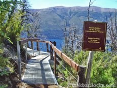
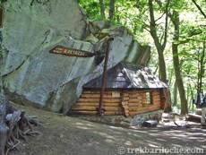
From the bus stop in the huge car park at the base of the Cerro Catedral ski resort, look for the wooden sign with 'FREY' written in big letters and the wooden carved backpacker (see photo below). The trail starts here. Head along the track away from the ski resort; after about 100m take the smaller trail signed off to the right. It crosses back over the vehicle track after about another 200m then forks to the right. Keep an eye out for the small signs bringing you onto the main trail. Once on this main trail, it's a very well marked path with excellent wooden and metal footbridges crossing a number of small stereams for about 1½ - 2 hours until you reach the path junction with the trail coming from Los Coihues. Keep heading up the valley for about another 1½ - 2 hours as the path starts to ascent into the forest, first crossing over the Van Titter stream on a larger metal footbridge, past Refugio Piedritas (a small shelter) before coming out above the tree line for the final kilometer to Refugio Frey.


Water
Early in the season there are a few streams in the first 5km of the trail, but they tend to dry up as the summer season progresses. The trail crosses a bridge over the Van Titter stream and this is the last option for water before arriving at refugio Frey.
Transport
Bariloche - Villa Catedral (Cerro Catedral ski resort): During summer there are public buses (Bus no. 55) about once an hour between 7.00am and 8.00pm starting from the Bus terminal, passing through the centre of Bariloche then alternately going along Avenida Bustillo and Avenida Pioneros. Get off at the last stop in the huge car park at the base of the ski resort.
If arriving by car you can park in the main ski resort car park at Villa/Cerro Catedral. The car park is generally a safe place to leave your car.
2) Frey por el Filo 
My favorite one day trek in the National Park and well worth the effort.
Overview
| Duration: | 4 hours trekking )one way) if using the cable car. |
| Distance: | 10 km's (if using cable car) to Refugio Frey; then another 12 km's if returning via the normal route. |
| Ascent: | 200m - If walking anti-clockwise (and using the cable car) 1200m - If walking clockwise |
| Start: | Villa Catedral (base of Cerro catedral ski resort) |
| Finish: | Refugio Frey |
| Difficulty: | Medium |
| Access: | Easy - hourly public bus |
| Park Entrance $: | None |
| Notes: | Probably the most spectacular one day walk in the National Park. |
The Route
From the Cerro Catedral resort car park head to the ticket office to purchase you lift ticket. Take the Gondola 'Amancay' then the 'Diente de Caballo' chairlift to the top; follow the track about 1km as it that gradually ascends, with the last 100m of steeper ascent over loose scree to the pass. Ascent $590 (Dec 2018) check times and days it operates: lift details. When you purchase your lift tickets you will probably be asked to sign a register so they have a record of who is doing the trail - this is different from the free/obligitory National Park trekking.
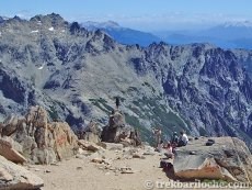
At the pass you have spectacular views over the Rucaco valley and the mighty glaciated Monte Tronador (3484m) in the distance. From the pass, the start of the trail is fairly obvious but is over loose rock and scree (Pay attention to the route markers and trail on the ground. Only precede if you're certain you are on the trail. If in doubt backtrack to the last seen marker to relocate the trail). The trail first descends to a section of easy scrambling then it's a traverse following red dots painted on the rocks until you reach 'Roca Inclinada' after about 2 hours. Pass through the 'Cancha de Futbol' (football pitch) an interesting flat (like a football pich - use a bit of imagination) col between the two valleys.
Still following the red dots, drop down (easy scramble) to Laguna Schmoll, then walk anti-clockwise around the lake for about 200m to a large minibus sized rock on the edge of the lake (there is a plaque on this rock). From here the trail follows the left hand side of the small stream flowing out of Laguna Schmall and zig-zags down one of numerous paths into the valley below. The trail countinues either to the left of the Laguna Toncek or crosses the flat bottomed valley to the right hand side of the laguna (take your pick!) arriving at Refugio Frey on the eastern shore of the Laguna Toncek.
Most people return via the normal route, descending through the forest, about 3 - 4 hours to the base of the ski resort at Cerro/Villa Catedral.
Water
The outlet of Laguna Schmoll, but this is only about 30 minutes before the refuge so bring with you what you need. If you take the chairlift you can stop in one of the cafes and buy bottled water and canned drinks etc.
Is the stream water safe to drink? As with any mountain region where lots of people trek, there will be pollution of water sources. The refuges provide safe drinking water; whilst out on the trails I would recommend treating water from streams. Recommended water filter: Sawyer Mini Filter (really small, practical & affordable!)
Transport
Bariloche - Villa Catedral (Cerro Catedral ski resort): During summer there are public buses (Bus no. 55) about once an hour between 7.00am and 8.00pm starting from the Bus terminal, passing through the centre of Bariloche then alternately going along Avenida Bustillo and Avenida Pioneros. Get off at the last stop in the huge car park at the base of the ski resort.
If arriving by car you can park in the main ski resort car park at Villa/Cerro Catedral. The car park is generally a safe place to leave your car.
(Tap image to open gallery)


3) Alternative route from Los Coihues 
About the same distance to Refugio Frey as from Cerro Catedral but adds about 250m of ascent. There is no advantage to doing this route.
Overview
| Duration: | 4 ½ Hours |
| Distance: | 12 km's return |
| Ascent: | 1000m |
| Start: | Los Coihues |
| Finish: | Refugio Frey |
| Difficulty: | Easy |
| Access: | Easy - hourly public bus |
| Park Entrance $: | None |
| Notes: | Easy one day trek |
The Route
The trail starts from Camping Lago Gutierrez (just outside Los Coihues). The path goes parallel but much lower down to the Normal route, joining this main trail after about 2½ hours. Public transport goes to Los Cohiues (Bus no. 50) which is about 2 kms from the campsite. This route adds about another 250m of ascent compared to the Normal route.
Water: Early in the season there are a few streams but they tend to dry up as the summer season progresses. The trail crosses a bridge over the Van Titter stream (after about 2 ½ hours) and this is the last option for water before arriving at refugio Frey.
Transport
Bariloche - Los Coihues. The trail starts about 2km from the bus stop! Buses every 20 minutes. Bus number 50. NOTE: You will need a rechargable bus pass or prepaid bus ticket to take this service. Ask at the Tourist Info or Mountain Info centres for up to date bus prices, and where to purchase tickets.
4) Refugio Frey to Refugio Jakob 
This trek is best walked in the Refugio Frey to Refugio Jakob direction and not vica verca due to descending the steeper scree slopes and not ascending them.
Overview
| Duration: | 6 Hours |
| Distance: | 9 km's |
| Ascent: | 600m |
| Start: | Refugio Frey |
| Finish: | Refugio Jakob |
| Difficulty: | Medium |
| Access: | Medium |
| Park Entrance $: | None |
| Notes: |
The Route
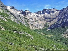
From Refugio Frey you can head out on the trail on either the left (crosses the small stream by Refugio Frey) or right hand side of Laguna Toncek. After walking past the lake the trail continues across the flat valley floor before zig-zagging up the right hand side of the valley to Laguna Schmoll; following red painted spots on rocks and small cairns to the right of a small stream. (There is a plaque on the large boulder by the lake shore). Continue clock-wise round Laguna Schmoll to the base of the easy scramble (from a distance it looks worse than it is) that ascends to the 'Cancha de Futbol' - a flat/sheltered pass between the two valleys. Carefully follow the markers to the start of the scree that descends steeply to the Ruco Valley below. It is not recommened to try and ascend this way especially with a large pack. A beautiful forest trail takes your through the valley floor before you start ascending again, heading out above the treeline to a col before the final scree/rocky descent to Refugio Jakob. There is a new bridge over a small stream and a new route cut through the forest on the final 300m before arriving at Refugio Jakob so you now don't need to get your feet wet on the previously very wet/muddy last section.
Water
From the outlet of Laguna Schmoll and there are a number of small streams in the Rucaco valley.
Is the stream water safe to drink? As with any mountain region where lots of people trek, there will be pollution of water sources. The refuges provide safe drinking water; whilst out on the trails I would recommend treating water from streams. Recommended water filter: Sawyer Mini Filter (really small, practical & affordable!)
(Tap image to open gallery)


Map for all Frey Treks
The Normal Route to Frey ![]() | Frey por el Filo
| Frey por el Filo ![]() | Alternative route from Los Coihues
| Alternative route from Los Coihues ![]() | Refugio Frey to Refugio Jakob
| Refugio Frey to Refugio Jakob ![]()
The information contained on this website is no substitute for a qualified Mountain Guide and the site author accepts no responsibility for inaccurate or outdated information (nor omission of information), nor any accident or injury sustained while carrying out the treks described here. This website has no affiliation to any of the refuges, businesses or organisations named withing it. All times and distances are approximate.